
27.6.11
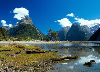
Milford sound and the Mitre peak New Zealand
The majestic scenery begins long before you reach Milford, in the Eglinton Valley. Snow-capped mountains loom 1000 metres above the road, streaked with waterfalls, and reflected in mirror lakes. The road climbs steeply into a sub-alpine wonderland at the Homer Tunnel entrance. You emerge from the tunnel to an instantly breathtaking view of the canyon which descends into Milford.
Milford Sound comes a close second to the mountains of Tahiti in recording the highest rainfall in the world. The deluge of 7 metres of rain each year sounds forbidding for a tourist resort, but it actually adds to the drama and mystique of the sound. In torrential rain the sheer mountain walls erupt with a thousand cascades plunging from hanging valleys, wreathed in ethereal mists, and crossed with rainbows.


Milford Sound comes a close second to the mountains of Tahiti in recording the highest rainfall in the world. The deluge of 7 metres of rain each year sounds forbidding for a tourist resort, but it actually adds to the drama and mystique of the sound. In torrential rain the sheer mountain walls erupt with a thousand cascades plunging from hanging valleys, wreathed in ethereal mists, and crossed with rainbows.

Milford sound and the Mitre peak

Milford sound and the Mitre peak

Milford sound and the Mitre peak

Milford sound and the Mitre peak

Milford sound and the Mitre peak
SHARE THIS POST


The Giants' Causeway Northern Ireland
Forget what the scientists say with pompous talk of volcanic eruptions and lava flows. Basically The Giants’ Causeway (the clue is in the title!) was formed by warring giants in Ireland and Scotland desperate to get at each other for a winner- takes-all fight.
Since neither of them could swim, to rumble and tumble they both built causeways to each other- seen today in Northern Ireland and on the Isle of Staffa in Scotland. These are the legacies to these titanic beasts. And the winner? Well, it didn’t really happen in the end but a sleeping Fionn MacCumhall (the Irish giant), too tired to fight after his strenuous building regime, was disguised as an infant by his wife- and his rival Benandonner, upon crossing the sea and seeing the “baby” felt that the difference in weight class could count against him if he was to fight the dad. So he slipped back to his homeland, taking the rest of the causeway with him. What an outrageous way to treat Northern Ireland’s cultural heritage! However, it is easy for us to say, sitting here in today’s western world with our espresso machines and books.
Since objectivity is the name of Tourist Attraction’s game, it is with heavy hand that we pen the scientist’s version of the origins of this majestic natural wonder too. Richard Dawkins might be after us too if we don’t.
So, as an Elvive advert might add, “here’s the science bit!” (taken from the Northern Ireland Tourist Board’s page on the causeway- a link to which is below).
Geology of the Causeway
“Geological evidence explains the Causeway as the aftermath of an ancient volcano. Sixty five million years ago, Antrim experienced intense volcanic activity, when fluid molten basalt broke apart chalk beds to form a lava plateau. When the molten lava hit the seawater, it cooled quickly and formed the polygonal columns. There were three periods of volcanic activity which resulted in the flows known as the lower, upper and middle basalts. The similar basalt formations at the site of Fingal’s cave on Staffa are part of the same lava flow which began in Antrim.”
Now that is an impressive lava flow. And what a superb remnant it has left behind- 40,000 interlocking basalt columns and Northern Ireland’s only World Heritage Site. The whole coastline around here is spectacular too.
And another bonus- did the giants offer the remaining parts of the causeway as a gift in perpetuity to the people of the world?- is that to visit the site is free, free, free!

The Giants' Causeway

The Giants' Causeway

The Giants' Causeway

The Giants' Causeway

The Giants' Causeway

The Giants' Causeway
SHARE THIS POST
24.6.11
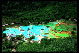
The limestone basins at Huanglong China
The limestone basins is in northern Sichuan Province, west-central China, in the southern part of the Min Shan Range about 230 km north of Chengdu. The Scenic Area is divided between two sites: Huanglong valley, 45 km northeast of Songpan town, which also includes the whole Fujiang river catchment above Shijiabao village; and the Muni valley, 15 km south-west of Songpan, which includes the catchments of the Zhaga travertine waterfall and the Erdaohai mineral lakes.
This is an outstanding karst landscape within the southern part of the Min Shan range which runs from the eastern huanglong_0_2Qinghai-Tibetan plateau down to the Sichuan basin. The Huanglong section of the reserve covers the catchment of 22 tributaries of the upper Fujiang River which has its source in Snow Mountain Ridge. The Huanglong valley itself is one of these tributaries. The slopes above the valleys are forested and steep, a spectacular example being the 15km long 700m deep Danyun Gorge of the Fujiang near Huanglong valley. Above the tree line the site is surrounded by mountains, their strata tilted into jagged peaks, three bearing glaciers, seven over 5000m high and all snow-covered for much of the year. The pyramidal summit of Xuebaoding (Snow-Treasure Peak) is permanently snow-covered and carries the easternmost glacier in China.


This is an outstanding karst landscape within the southern part of the Min Shan range which runs from the eastern huanglong_0_2Qinghai-Tibetan plateau down to the Sichuan basin. The Huanglong section of the reserve covers the catchment of 22 tributaries of the upper Fujiang River which has its source in Snow Mountain Ridge. The Huanglong valley itself is one of these tributaries. The slopes above the valleys are forested and steep, a spectacular example being the 15km long 700m deep Danyun Gorge of the Fujiang near Huanglong valley. Above the tree line the site is surrounded by mountains, their strata tilted into jagged peaks, three bearing glaciers, seven over 5000m high and all snow-covered for much of the year. The pyramidal summit of Xuebaoding (Snow-Treasure Peak) is permanently snow-covered and carries the easternmost glacier in China.

The limestone basins at Huanglong

The limestone basins at Huanglong

The limestone basins at Huanglong

The limestone basins at Huanglong

The limestone basins at Huanglong

The limestone basins at Huanglong

The limestone basins at Huanglong
SHARE THIS POST
The Coliseum Italia
Reconstruction of the Colosseum started from the command of King Vespasian in 72 M and completed by his son Titus in 80 M Colosseum established close to Nero’s enermous Palace, Domus Aurea that had been built in after the great fire in Rome in 64 M Some historians believe that construction of the Colosseum was financed by way of robbing a big temple in Jerusalem by order of King Herod in 64M.
Dio Cassius a historian said that there are about 9000 wild animals who have been killed in 100 days as a celebration of the inauguration and opening of the Colosseum. The floor of the Colosseum arena was covered by sand to prevent blood-the blood does not flow anywhere.
Performances
Colosseum at that time was the venue for a spectacular show, which is a fight between animals (venetaiones), the fight between prisoners and animals, the execution of prisoners (noxii), water fight (naumachiae) by flooding the arena, and the battles between gladiators (munera) . For hundreds of years, the estimated thousands of people and animals die in the Colosseum show.

The Coliseum

The Coliseum

The Coliseum

The Coliseum

The Coliseum

The Coliseum
SHARE THIS POST
The Piano rocky inlet and the Girolata gulf France
This nature reserve on the west coast of Corsica is centred on the Gulfs of Porto and Girolata between the craggy Scandola peninsula to the north and the turrets of the Calanche of Piana to the south. The vegetation is an outstanding example of Mediterranean maquis. Seagulls, cormorants and ospreys abound. The clear waters, their islets and inaccessible caves, harbor a rich marine life which includes a huge range of algae.
Three great ridges, the Elbo peninsula, Capo Senino and Capo Rosso divide the area into three distinct areas: the coast between Punta Stollo and Punta Muchillina, including the peninsula of Scandola; the Gulf of Girolata from Punta Scandola to Capo d’Osani on Cape Senino; and the Gulf of Porto from Capo Senino to Punta Bianca plus its southern coast to Capo Rosso including the calanche below Piano.


Three great ridges, the Elbo peninsula, Capo Senino and Capo Rosso divide the area into three distinct areas: the coast between Punta Stollo and Punta Muchillina, including the peninsula of Scandola; the Gulf of Girolata from Punta Scandola to Capo d’Osani on Cape Senino; and the Gulf of Porto from Capo Senino to Punta Bianca plus its southern coast to Capo Rosso including the calanche below Piano.

The Piano rocky inlet and the Girolata gulf

The Piano rocky inlet and the Girolata gulf

The Piano rocky inlet and the Girolata gulf

The Piano rocky inlet and the Girolata gulf

The Piano rocky inlet and the Girolata gulf
SHARE THIS POST
The Yellowstone national park United States of America
Yellowstone National Park, first established as a federally protected park in 1872, was the first park to reach this status in the United States. The park spans three states, stretching from Wyoming out into Idaho and Montana. The largest section of the park, however, is located within the state of Wyoming, and for this reason travel to this state is centered on the park attractions. Yellowstone is famous as a park which allows animals to run free throughout its hundreds of thousands of acres undisturbed. Bears, elk, bison, birds and more wander unhindered through this beautiful park, and travelers can drive or walk through the park at their own will.
In 1872 President Ulysses S Grant, "set apart as a public park or pleasuring ground for the benefit and enjoyment of the people. This park contained 2.2million acres of wilderness that was completely unspoiled beauty. However, within 20 years financial support for the park began to dwindle, because of the lack of the ability of the common man to see the glory of Yellowstone National Park. Eventually, through litigation and luck the railroads began to cater to the common tourist bringing money and visitors to a Yellowstone. With the invention and mass production of the automobile visitors to Yellowstone more than quadrupled. Making Yellowstone one the premiere destinations for family holidays in the 1940's and 1950's.In the 1970's attention strayed away from the History of Yellowstone National Park and became more about the conservation of Yellowstone Park itself. For futher information visit Yellowstone National Park


In 1872 President Ulysses S Grant, "set apart as a public park or pleasuring ground for the benefit and enjoyment of the people. This park contained 2.2million acres of wilderness that was completely unspoiled beauty. However, within 20 years financial support for the park began to dwindle, because of the lack of the ability of the common man to see the glory of Yellowstone National Park. Eventually, through litigation and luck the railroads began to cater to the common tourist bringing money and visitors to a Yellowstone. With the invention and mass production of the automobile visitors to Yellowstone more than quadrupled. Making Yellowstone one the premiere destinations for family holidays in the 1940's and 1950's.In the 1970's attention strayed away from the History of Yellowstone National Park and became more about the conservation of Yellowstone Park itself. For futher information visit Yellowstone National Park

The Yellowstone national park

The Yellowstone national park

The Yellowstone national park

The Yellowstone national park

The Yellowstone national park

The Yellowstone national park
SHARE THIS POST
The maya city of Chichen Itza Mexico
The list of new world wonders includes The Great Wall of China, Petra, Christ the Redeemer, Machu Picchu, The Colisseum, and Taj Mahal
The Mayan city of Chichen Itza, located in the Mexican state of Yucatan, was chosen as one of the "Seven New Wonders of the World" by approximately 100 million people around the globe, who cast their ballots by phone and Internet.
"The selection of Chichen Itza is recognition of the extremely vast and ancient historical and cultural heritage of Mexico, of which very few countries in the world can boast," said Francisco Lopez Mena, CEO of the Mexico Tourism Board.
The announcement of Chichen Itza's selection by the New7Wonders Foundation was made during a spectacular ceremony at Lisbon's Stadium of Light.
The archaeological center of Chichen Itza, the most important Maya capital at the end of the classic period (750 to 1200 A.D.), was declared a UNESCO World Heritage Site in 1988.
Chichen Itza, which in the Mayan language means "at the mouth of the well of the Itza," was one of the most important Mayan political, commercial and religious centers of the classic period, but it fell into decline after the emergence of Mayapan as the new focal point of regional power in the Yucatan Peninsula.
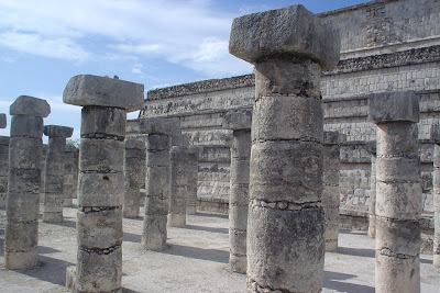
The city is home to several buildings that are remarkable both for their architectural design and their religious and scientific significance. Among these are the Temple of Kukulkan (Feathered Serpent), the Observatory, the Temple of the Warriors and the Sacred Cenote (Well of Sacrifice).
The Temple of Kukulkan, one of the tallest and most notable structures in Mayan architecture sits on a 55.5-meter wide rectangular platform and rises to a height of 24 meters. Each of its four sides has 91 steps and the platform that crowns the pyramid is considered the 365th step, meaning there is one for each day of the solar calendar.
During the spring and fall equinox (March and September), visitors can enjoy a breathtaking spectacle: a corner of the Temple of Kukulkan casts a shadow in the shape of a giant "feathered serpent" that appears to slither its way down the side of the North staircase with the sun's movement. This natural phenomenon of light and shadow is a unique experience that attracts visitors from all parts of the world.
The Observatory, also known as "El Caracol" (The Snail) for its stone spiral interior staircase, is a cylindrical building with a dome that was used as an astronomical observatory, with its doors aligned to view the spring equinox, the declinations of the Moon and other astronomical events that helped determine the complex but extremely exact Mayan calendar.
Other popular sites at Chichen Itza are the Great Ballcourt - which, measuring 168 meters long and 70 meters wide, is the largest that has been discovered in the region known as Mesoamerica - and the Sacred Cenote, a large sinkhole 60 meters in diameter from which great treasures have been recovered: rings, necklaces and objects of gold and jade.


The Mayan city of Chichen Itza, located in the Mexican state of Yucatan, was chosen as one of the "Seven New Wonders of the World" by approximately 100 million people around the globe, who cast their ballots by phone and Internet.
"The selection of Chichen Itza is recognition of the extremely vast and ancient historical and cultural heritage of Mexico, of which very few countries in the world can boast," said Francisco Lopez Mena, CEO of the Mexico Tourism Board.
The announcement of Chichen Itza's selection by the New7Wonders Foundation was made during a spectacular ceremony at Lisbon's Stadium of Light.
The archaeological center of Chichen Itza, the most important Maya capital at the end of the classic period (750 to 1200 A.D.), was declared a UNESCO World Heritage Site in 1988.
Chichen Itza, which in the Mayan language means "at the mouth of the well of the Itza," was one of the most important Mayan political, commercial and religious centers of the classic period, but it fell into decline after the emergence of Mayapan as the new focal point of regional power in the Yucatan Peninsula.
The city is home to several buildings that are remarkable both for their architectural design and their religious and scientific significance. Among these are the Temple of Kukulkan (Feathered Serpent), the Observatory, the Temple of the Warriors and the Sacred Cenote (Well of Sacrifice).
The Temple of Kukulkan, one of the tallest and most notable structures in Mayan architecture sits on a 55.5-meter wide rectangular platform and rises to a height of 24 meters. Each of its four sides has 91 steps and the platform that crowns the pyramid is considered the 365th step, meaning there is one for each day of the solar calendar.
During the spring and fall equinox (March and September), visitors can enjoy a breathtaking spectacle: a corner of the Temple of Kukulkan casts a shadow in the shape of a giant "feathered serpent" that appears to slither its way down the side of the North staircase with the sun's movement. This natural phenomenon of light and shadow is a unique experience that attracts visitors from all parts of the world.
The Observatory, also known as "El Caracol" (The Snail) for its stone spiral interior staircase, is a cylindrical building with a dome that was used as an astronomical observatory, with its doors aligned to view the spring equinox, the declinations of the Moon and other astronomical events that helped determine the complex but extremely exact Mayan calendar.
Other popular sites at Chichen Itza are the Great Ballcourt - which, measuring 168 meters long and 70 meters wide, is the largest that has been discovered in the region known as Mesoamerica - and the Sacred Cenote, a large sinkhole 60 meters in diameter from which great treasures have been recovered: rings, necklaces and objects of gold and jade.

The maya city of Chichen Itza

The maya city of Chichen Itza

The maya city of Chichen Itza

The maya city of Chichen Itza

The maya city of Chichen Itza
The maya city of Chichen Itza
SHARE THIS POST
22.6.11
The Potala, dalai-lama's palace China / Tibet
When Tibetans wander the Potala Palace's dark halls and shrines, their worshipping appears as a sobbing of souls. Lhasa's majority Chinese enjoy the palace's physical beauty, perched on a small, central outcrop called Red Hill, surrounded by flat city streets. But the Chinese do not pilgrimage in reverence to the Dalai Lama's empty throne.
Han Suyin, an apologist author for Chinese rule over Tibet, wrote in her book, "Lhasa, The Open City," that the Potala was a "termite nest" and "an evil, parasitic monster, despite the glamor." A wealthy Chinese businessman, waiting his turn at the Bank of China within sight of the palace, said he didn't know much about the Potala, though he passed by nearly every day. "That place? No, I haven't gone in. Is it worth visiting?" he asked in an interview. He was curious about the Potala's value, but not as an advertising logo. Squinting at the Potala's mammoth white walls, he asked, "How much does it cost to see inside?"


Han Suyin, an apologist author for Chinese rule over Tibet, wrote in her book, "Lhasa, The Open City," that the Potala was a "termite nest" and "an evil, parasitic monster, despite the glamor." A wealthy Chinese businessman, waiting his turn at the Bank of China within sight of the palace, said he didn't know much about the Potala, though he passed by nearly every day. "That place? No, I haven't gone in. Is it worth visiting?" he asked in an interview. He was curious about the Potala's value, but not as an advertising logo. Squinting at the Potala's mammoth white walls, he asked, "How much does it cost to see inside?"

The Potala, dalai-lama's palace

The Potala, dalai-lama's palace

The Potala, dalai-lama's palace

The Potala, dalai-lama's palace

The Potala, dalai-lama's palace

The Potala, dalai-lama's palace
SHARE THIS POST
Aerial view of Rio bay Brazil

Aerial view of Rio

Aerial view of Rio

Aerial view of Rio

Aerial view of Rio

Aerial view of Rio

Aerial view of Rio
SHARE THIS POST
Subscribe to:
Posts (Atom)


0 comments: